
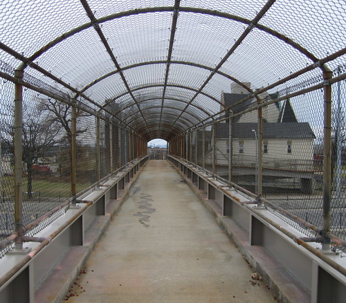
While poking around the Fruit Belt on Sunday afternoon, I walked over the pedestrian bridge connecting Mulberry Street with Hickory on the other side of the 33. Here's the map!


click image to enlarge
Really sort of odd walking this path - despite my rather intrepid urban exploration orientation - as it's really an after thought making room for pedestrians or bicyclists in their desire to cross the 33. It's an envionment designed for getting people around in cars. Simple. Like to know if these pedestrian bridges were part of the original design of the 33 or some sort of after thought.
While checking out some of the houses in the lower Belt I started thinking about the correlation of realestate values and the proximity to high volume urban highways like the 33. Further up and just north of the Museum of Science is 2 Girard, just sitting and rotting. Wonder if proximity to 33 and lower realestate values is anecdotal or could be backed up by some real data. Anyone?
Next weekend, another pedestrian crossing.
See also - Reconnecting Buffalo
click image to enlarge
While checking out some of the houses in the lower Belt I started thinking about the correlation of realestate values and the proximity to high volume urban highways like the 33. Further up and just north of the Museum of Science is 2 Girard, just sitting and rotting. Wonder if proximity to 33 and lower realestate values is anecdotal or could be backed up by some real data. Anyone?
Next weekend, another pedestrian crossing.
See also - Reconnecting Buffalo
__________________________________________________________________________
Artspace Archive • Annals of Neglect • BAVPA • Where is Perrysburg? • Broken Promises...
Writing the City • Woodlawn Row Houses • faq • my flickr
Artspace Archive • Annals of Neglect • BAVPA • Where is Perrysburg? • Broken Promises...
Writing the City • Woodlawn Row Houses • faq • my flickr
3 comments:
what a metaphor these are, and how many times i have driven under them...funny that their design is so prison like. keep your focus ü ä
agree...Ö
jwfisher...
looked for signage...couldn't find. Will look at the other ped - bridges crossing the scar, very soon.
Post a Comment