
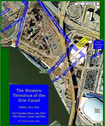
click image to enlarge
Take a moment to click through some of the links here - Erie Canal Links - no doubt the most comprehensive set of links and resources to help you better understand the significance of what's at stake. The alternative? Paving over our heritage, again...go figure.
The recent background information can be found here - Erie Canal Harbor Project. Many of the documents - years of community based work, stitched together by members of this community are available using that link. The recent plans presented by Larry Quinn conveniently overlook this fact. Wrote something about this - (b)Ass Pro - last month.
The recent background information can be found here - Erie Canal Harbor Project. Many of the documents - years of community based work, stitched together by members of this community are available using that link. The recent plans presented by Larry Quinn conveniently overlook this fact. Wrote something about this - (b)Ass Pro - last month.
__________________________________________________________________________
Artspace • BAVPA • Tour d'Neglect - 2007 • Woodlawn Row Houses • faq • my flickr
the creativity exchange • CEOs for Cities
Artspace • BAVPA • Tour d'Neglect - 2007 • Woodlawn Row Houses • faq • my flickr
the creativity exchange • CEOs for Cities
2 comments:
I am not getting your point. No one and no plan has ever proposed replicating all these roads and canals. The BP project does not conflict with anything proposed and approved so far and as a matter of fact brings the plan closer to the historic patterns by eliminating a big empty plaza at the water edge. Does anyone believe that a festival market place plaza was ever part of Buffalo's historic water front.
I concur with Steel.
Larry Quinn said it very succinctly in yesterday's News column:
[begin quote]Although the corporation’s plan for Bass Pro and Canal Side adheres to this step-by-step process, it does not deviate in any material way with the goals and intent of the original Canal District Master Plan. Like the old plan, the new plan retains the historic cobblestone streets and the river walkway and floating pier on the water’s edge. The interpretive exhibits along the canal will be built where they were always intended. No building will be built in excess of the pre-established design standards. Although the Aud and the unsightly Donovan State Office Building finally will be torn down, no historic structures will be demolished. Parking structures will be built with historic facades and liner buildings that will disguise their true function, just like their counterparts at Boston’s historic Faneuil Hall and Baltimore’s Inner Harbor.
There is only one difference between the new plan and the old one. Instead of placing plaques in the ground commemorating the site of the Central Wharf building, the new plan proposes to actually reconstruct the original building in all its glory. That will necessitate shifting the public plaza to the area adjacent to the canal historic artifacts. Given wind, weather and functionality, the new plaza location seems more appropriate anyway.
There is one more difference. The development corporation’s plan is not intended to sit on a bookshelf gathering dust with the rest of the plans that have been hatched and discarded over the decades. It is a realistic plan with a dream, a vision and, most importantly, credible people who are willing to invest real money to make it reality. It is anything but “desperate.” Unfortunately, this is where “Esmonde and Company” get lost.[end quote]
...I can understand someone being against the $25 million that's going to be spent on this. I can't fathom why anyone would be opposed to the overall project's design (which is still subject to change based on the input of a panel of local architects) based on the fight that took place at the turn of the century.
Post a Comment