Here's the official invitation to participate in a community meeting on Wednesday December 3rd for a full discussion regarding the future of the most interesting and perhaps least understood part of the City, it's past and promise. Buffalo Rising covered it here.
So...imagine for a moment - a discussion about Delaware Park, without talking about down-grading the Scajaquada Expressway. Or, imagine for a moment a discussion about the possibility of East side revitalization that doesn't include a discussion regarding the feasibility and necessity of decking the 33. Impossible, right? Well the same thing is happening here. Route 5 is not part of this plan! It bisects this part of the planet! How can a 'master plan' for the area not even mention this 800lb gorilla?
Covered by B/R in October 2007 - Will the Ghost of Robert Moses Continue to Haunt Us - (do a search for 'waterfront coalition' on buffalorising to get up to speed) I find it almost insulting that the BOA planning area conveniently ends/begins at route 5. I've driven this construction site all summer and fall with a rather intrepid critic of this process and we've been continually miffed and upset by the wholesale lack of integrated and regional planning for this part of the planet.
If the current re-construction of route 5 continues reasonable planning for the rest of this area will be negatively impacted for decades. It will take generations to undue what we can still stop today. Nationally, Congress for the New Urbanism has endorsed the boulevard option, right here. Locally, Julie Barrett O'Neill, Executive Director of the Buffalo Niagara Riverkeeper (follow that link for updated current legal action) is featured in the following ten minute video explaining why we can't wait.
Prior to the meeting please take a moment to familiarize yourself with the planning documents that are available here on the City's website. Particular attention should be paid to the draft document - Analysis of the Proposed BOA - September 2008 [.pdf files after the jump] that's been compiled and written by Urban Strategies, Inc. - a Toronto based urban planning and design firm. I've learned that they're receiving $600K+ for this work. It's a short 100pp document with two rather interesting appendixes.
Two comments from the growing Buffalo Rising comment stream include...I've spent a good deal of time exploring and photographing this part of Buffalo with artists and photographers from Berlin to San Francisco. Really amazing space. The industrial landscape is fading away and the last remaining physical elements of this place - a place that is so infused with the City's ethos and industrial past and promise - are being reduced to dust or shipped off to China as scrap, right now. Globally there are some amazing models out there including Emscher Park in Germany that could be embraced here and now when thinking about this space and planning its future use.
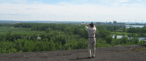
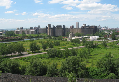
...you can see the land in question encompasses both Tifft, the Buffalo River and the lands surrounding the grain elevators - elements unique to Buffalo's connection to the past and future. One only has to take a boat down the Buffalo River on a summer day to see the potential of this place. 1900 acres is a lot of land.
As the article asks - what kind of city do we want? A city with access to our resources? A city that serves it's citizens? A city that serves the special interests of a few? A city that can move into the future with vision rather than short-sightedness? Without public input who will decide?
By creating two planning areas - the 'outer harbor' and the south Buffalo BOA - the community and the City are being divided - by a highway and the Brown administration that continues to possesses and impose a myopic view of Buffalo's future. It's text book, divide and conquer. Or, where's the strategic, long-term regional planning that should include other parts of the area - Bethlehem Steel, for example and the brownfield remediation that's happening there that Tecumseh ReDevelopment is completing. It's a stone's throw a way from this 1900 acre South Buffalo BOA planning area. Why are we competing with the City of Lackawanna for scare resources now? Could the cash being pipelined for this area be used more effectively in other parts of the second third poorest city in the country? So many questions.
As we prepare for Wednesday evening, let's remember Jane Jacob's life and work.It may be that we have become so feckless as a people that we no longer care how things do work, but only what kind of quick, easy outer impression they give. If so, there is little hope for our cities or probably for much else in our society. But I do not think this is so.Meeting begins at 5:30pm at the Buffalo Irish Center, 245 Abbott Road.
- Jane Jacobs, The Death And Life of Great American Cities, 1961
__________________________________________________________________________
Artspace • BAVPA • Woodlawn Row Houses • fixBuffalo flickr
Creative Class • Shrinking Cities • Saturdays in the neighborhood
Artspace • BAVPA • Woodlawn Row Houses • fixBuffalo flickr
Creative Class • Shrinking Cities • Saturdays in the neighborhood


7 comments:
Good post, Dave!
It is beyond baffling that any discussion can occur about the future of South Buffalo's vast industrial landscape while ignoring what you aptly dub the 800-lb gorilla: Route 5.
A blighted, elevated highway rips through the area and it, perhaps conveniently, is ignored. As you point out, the border of the study area stops at the berm that leads up to the highway. Every goal the consultants must be evaluating is deeply, deeply affected the presence of the highway.
Perhaps if the consultants opened a temporary office next to the wall, they'd realize how silly it is not to talk about it. Then again, the unbearable roar of high speed traffic would drown out the conversation and they wouldn't be able to hear themselves talk, so the point might not get across!
Perhaps enough folks can stop by this meeting to remind them of that...
I think that the study itself ends at Rt. 5 shows exactly how it separates the rest of south Buffalo from the water front land.
Stopping at Route 5 was not the consultant's choosing, it was the City's.
For those who attended the last meeting at the Irish Center, when this question was raised the Urban Strategies folks hinted that this was frustrating to them (in a very polite way, they are Canadian after all) and said something along the lines of "maybe we can look at incorporating the outer harbor in the remainder of the study". No dice.
Why would the city not want route 5 included in this 'master plan'?
Mr. Torke. Three questions:
1) What do you mean by "decking the 33", (which is the Kensington Expressway)?
2) Legally, expressways are not pedestrian crossings, but, isn't it the Kensington Expressway for which that legal requirement was never enacted--making it just another city street, which might throw a wrench into any other legalities?
3) I think you should know this: Today, everytime I click into fixbuffalo from my Favorites List, and only fixbuffalo, an anti-virus alert windows comes up!
As I am on here, the count goes from 4 to 6. There are also 6 deletes as my virus protection deletes them, but where do they keep coming from and why only here at fixbuffalo?
If I click into something else then come back here, back come the same 6 infections! Actns/Swif.T
I will check back later or tomorrow for replies.
Crisa,
Decking the '33' includes covering the highway from the 'hourglass' - where it merges with the '198' - to Jefferson Avenue. This has been widely discussed as a way of stitching the neighborhood back together.
I don't know about the legal issue you're raising. Perhaps someone here with more knowledge can explain this.
As far as your 'virus issue' sorry to hear this. I log in to my blog from a variety of places - coffee shops and wireless networks all over the city - and haven't run into this problem. I use a 'macbook' and haven't encountered this problem. I'm sure the good people in Mountain View are on top of virus issues. I'll ask around.
That virus didn't interfere with anything and isn't coming up today.
It also isn't findable on my computer.
I don't go to places that are not secure and I always choose "no" when the window comes up about if I want unsecured stuff to come up.
(This morning I remembered that a while back, something similar happened after our grands went on(my)line to myspace, facebook and that kid stuff.)
Thanks for answering about decking the 33. I remember before the expressways.
I remember the houses that used to be where the Kensington Expressway is.
I remember the beautiful, parklike Meyer Memorial Hospital grounds (ECMC now).
Heck, I vivedly remember Humboldt Parkway when it actually was a lovely parkway complete with horseback riders and picnickers!
I understand how badly the expressway cut up neighborhoods.
About people crossing expressways:
A few years back, it was on TV newscasts and in the local newspaper that people were crossing one of Buffalo's expressways and the police were attempting to stop that dangerous happening. (I think it is the Kensington Exp.). But there was no ability for enforcement because the necessary legalities were never enacted.
Post a Comment