
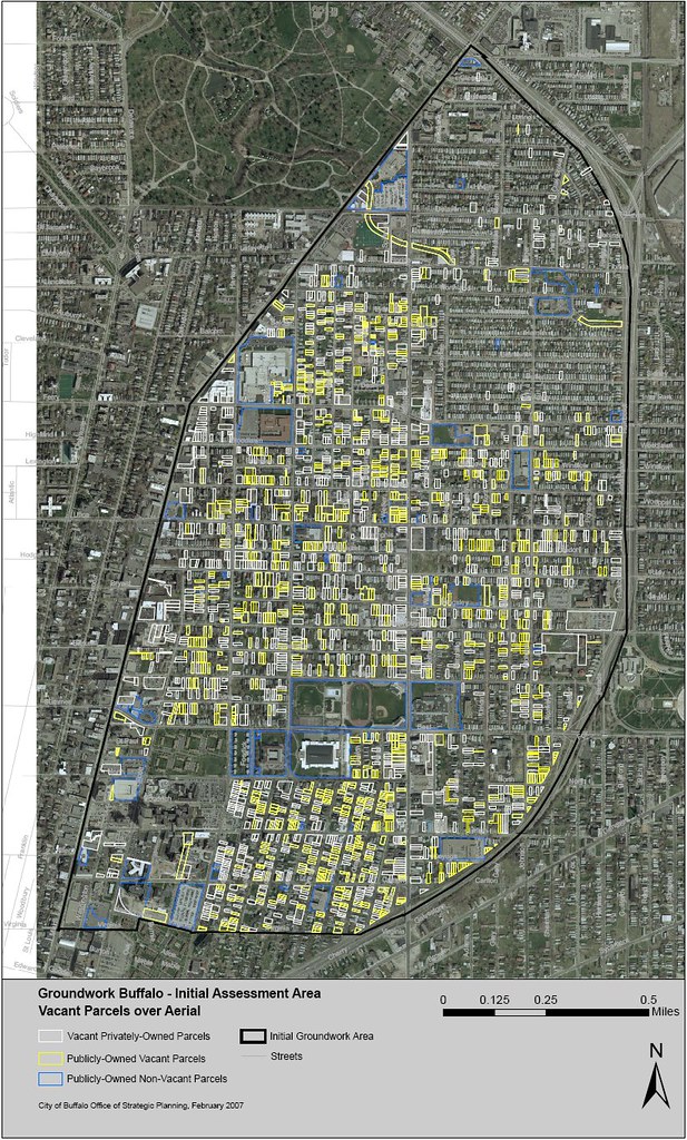
A frequent fixBuffalo reader just sent along this pic. Yikes! Check out the key at the bottom...
click image and "all sizes" for larger view
__________________________________________________________________________click image and "all sizes" for larger view
Data is from the City of Buffalo's 9th floor...and conforms to the reality many residents and visitors to Buffalo's near East side experience on a regular basis.
Learn more about abandonment, shrinking cities and vacancy - right here.
Learn more about abandonment, shrinking cities and vacancy - right here.
Artspace Archive • Annals of Neglect • BAVPA • Where is Perrysburg? • Broken Promises...
Writing the City • Woodlawn Row Houses • faq • my flickr
the creativity exchange
11 comments:
What is meant by vacant parcel. Do they mean no building on the site or no people in the building or both?
I would be curious to see similar analyses on other neighborhoods, too; do you know if this is part of a larger project (or series of projects)? Thanks for posting it, though. 'Tis provocative indeed...
Yeah, their use of word "vacant" confused me too.
But since there's hardly any blue markings for "non-vacant", and based on huge amount of yellow, I'm guessing that "public vacant parcel" category must include sites with buidings such as city-owned abandoned houses (forclosures), as well as city-owned empty lots. So vacant would mean "unoccupied" as well as what normal peole would call vacant ("empty")?
Notice there's very few "public non-vacant" blue markings, so that category probably includes anything owned and in use by a govt agency.
all the yellow makes that area seem radioactive.
Makes me wonder who the city and county politicians "representing" the East Side actually represent? Isn't this the area that the present mayor and newly elected NYS Assemblyman come out of?
Reminds me of the story about former Chicago Mayor Richard Daly and President JFK riding in a motorcade shortly after Kennedy's election and waving at the crowds. When the parade took a shortcut through a cemetary, JFK began to sit down. Daly grabbed his arm and told him to "keep waving, you got as lot of votes out of this district."
a vacant parcel generally means land without a building on it.
a vacant building would still be classified as a single-family house, two-family house, etc.
so it seems as though the white and yellow are all empty lots, but the blue would still have structures, even if those structures are empty.
Hey Mayor B - Looks like you've got your work cut out for you! No more time spent at award ceremonies.
BTW, I think vacant can mean empty land parcel or structure since the word by definition means contain nothing, empty, unfilled. Maybe Fix knows.
Thanks for the interest here...
Just got off the phone with a well placed source...this is an image taking GIS stuff and imposing it on a satellite image.
1. GIS does not pick up vacant properties. The white and yellow spots on the map are empty lots, only.
2. The GIS info is current as of 12/2006. It's pretty close to what's on the ground.
3. GIS only picks up property classification codes.
The BIG issue here is that empty houses are NOT included in this image...this is just the "urban prairie"...and not houses that are abandoned, boarded, derelict and vacant.
NO ONE - 3rd floor, 9th floor...or even now an out-dated Fire Dept. study/evaluation of abandonment and vacancy gets their hands around the full extent of the problem...
It's getting worse by the week...
If you scan over Buffalo (in Google earth) ... specifically the east side you will see vast tracks of blocks that appear more park-like than residential. This is an important issue and asks us to think of how our city will evolve and what things we need to do to get the best outcomes from these changes.
Hey, what's the narrow snaking parcel coming out of Forest Lawn at the SE corner? It looks like it traces the path of the Scajaquada, which was undergrounded almost 100 years ago.
The "narrow snaking parcel" referenced just above is, I believe, the route of the buried Scajaquada.
I once heard that there was a public right-of-way on top of this drain for its entire length, and one day last summer I set out to trace it on a bike. Sure enough, you can follow it all the way out to where the Creek ducks underground at Pine Ridge Road in Cheektowaga (save a short section in the industrial zone between Fillmore and Grider)...
It was a neat Buffalo adventure, anyway. :)
Post a Comment